Mau evictions: Govt and squatters clash over boundary
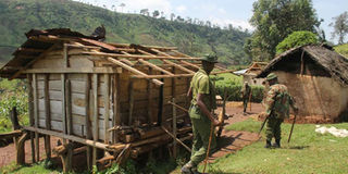
Kenya Forest Service officers at a deserted home in the Maasai Mau Forest on September 6, 2019. PHOTO | JOHN NJOROGE | NATION MEDIA GROUP

What you need to know:
- A dispute over the Maasai Mau Forest boundary has put Mr Natembeya on a collision path with Rift Valley leaders who accuse him of creating a new cut-line in the ongoing evictions.
- Illegal extension of group ranches in 1997 created 1,962 parcels of land measuring about 14,103.7 hectares.
- Sisian, Enainkishomi, Reiyo, Enoosogon and Enkaroni ranches had boundaries stretched about 10 times.
The dispute over Maasai Mau Forest boundary has put the squatters on a collision path with the government over which is the genuine cut-line in the ongoing evictions.
Squatters, who are now moving out of the forest, say the cut-line they know is the Nyayo Tea Zone. But the government insists the legal boundary is the one established in 2008 on the recommendation of a task force set up to look into ways of saving the Mau Complex.
EVICTIONS
But according to one of the squatters Mr Joseph Langat of Sierra Leon, the cutline they refer to is a 24-kilometre Purple tea buffer zone between the Olpusimoru Forest and human settlement in the Maasai Mau where squatters are being evicted.


And like most of those affected by the evictions, Mr Langat argues they are not in the forest. However, they were found to be within the cutline.
In the 2015 cut-line, the Nyayo Tea Zone planted purple tea in a 24 kilometre area creating a buffer zone in a bid to separate the Maasai Mau section of the forest under the county government of Narok with Olposimoru Forest which is managed by Kenya Forestry Services.
The tea buffer zone lies between Amalo and Ewaso Ngiro River. The buffer zone which measures 300 meters in width, has been used by the illegal settlers and politicians as the cutline of the forest.
But the government is using the Mau Task force in 2009/2010 cutline where it profiled 7,989 and commonly referred as ‘the Status quo area’ where people were left to dwell in the forest until the government makes the next course of action.
MAASAI MAU
But according to Rift Valley Regional Commissioner George Natembeya, the tea zone cut-line was only to separate the Ol Posimoru Forest and the Maasai Mau and not to determine the boundary.
“The buffer Zone have also stood as a barrier for wildlife migrating from Maasai Mau, Transmara Forest to Olpusimoru Forest causing a big stress to the wildlife especially elephants,’ said Mr Natembeya.
This was reached after an independent government team, reportedly led by senior police officials, completed an independent audit of the forest boundaries and the tea zone.
A dispute over the Maasai Mau Forest boundary has put Mr Natembeya on a collision path with Rift Valley leaders who accuse him of creating a new cut-line in the ongoing evictions.
While Senate Majority Leader Kipchumba Murkomen, Kanu chairman Gideon Moi, former Bomet Governor Isaac Ruto, Kericho Senator Aron Cheruyiot and a host of Jubilee MPs from the region argue that the cut-line should be the Nyayo Tea Zone but the government insists that the only legal boundary is the one set out in 2009.
Speaking in Sogoo High School in Narok South, Deputy President William Ruto asked those living beyond the cutline to move out saying environmental conservation was crucial for the country.
“Those who live inside the forest will be moved out. We have planted tea to separate the forest and the settlement area as we have to conserve our environment,” he said.
BOUNDARY
The evictions started July to September last year when the government conducted phase one of the exercise between Nkoben River north boundary and Kosia.
About 3,000 head of livestock were removed but crops were spared. Approximately 11,119.725 acres (4,500 hectares) were recovered.
A profiling exercise in 2008 targeting 7,971 households showed that over 30 per cent (2,436) households have no documents to support their occupation.
Environment CS Keriako Tobiko took issue with ranch owners whom he accused of expanding their ranches from 17,297.35 acres (7,000 hectares) to 42,007.85 acres (17,000 hectares).
Mr Tobiko said the encroachments have caused a crisis.
Various reports on conservation initiatives say that had it not been for the extension of boundaries of five group ranches that border Maasai Mau, there would not have been settlements inside the forest.
A May 2017 United Nations Environmental Programme (Unep) report estimates that because of years of destruction, the Mau Forest tree cover is at a critical 1.7 per cent.
14,278 HECTARES
Between 1973 and 1986, the report says, 14,278 hectares of Maasai Mau were destroyed.
The entire 427,000 hectare Mau Complex was gazetted as a forest reserve in 1954.
Illegal extension of group ranches in 1997 created 1,962 parcels of land measuring about 14,103.7 hectares.
The extension, which encouraged massive encroachment, now stands at about 20,000 hectares after further changes were made in 1997 to accommodate more people.
Sisian, Enainkishomi, Reiyo, Enoosogon and Enkaroni ranches had boundaries extended about 10 times.
Sisian’s boundary was extended from 447.5 hectares to 1,215 hectares and sub-divided into 383 sub-plots.
Among the sub-plots was Narok/Cismara section 374, whose area was 6.28 hectares. It was divided into 45 parcels.