Trip to Africa’s largest wildlife protected area
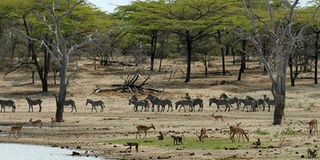
Tanzania's Selous Game Reserve. It is Africa’s first and largest wildlife protected area. PHOTO | COURTESY
What you need to know:
- The drive on Kilimanjaro’s shoulder through a scenic winding road is even greener, with rivers gushing down Africa’s tallest massif.
- When I tell them about the “only found” kinds of wildlife, like the Amani sunbird, in the old forests, they turn to look at the wizened hills with new respect.
Over 1,000 kilometres south of Nairobi, the road less travelled is to southern Tanzania to explore Africa’s first and largest wildlife protected area.
It used to be the Selous Game Reserve, part of which was renamed Nyerere National Park in 2019. Nyerere, the respected Mwalimu, was Tanzania’s founding father.
The entry to East Africa’s largest nation is through Tarakea, the border post past Kenya’s Amboseli National Park that’s so green and lush, with a herd of 40 giraffes nibbling on the acacia outside the park.


At the border, the dense, white clouds part for a few minutes to reveal a sliver of Mr Kilimanjaro’s snowy peak, and with passports stamped at the not-busy border offices, we’re officially in Tanzania.
The drive on Kilimanjaro’s shoulder through a scenic winding road is even greener, with rivers gushing down Africa’s tallest massif.
MIGHTY PANGANI
We stop for lunch at Marangu, which means “a place of many rivers” by a huge, whitewashed cathedral that faces the tiny one built during the German regime around the 1800s.
Banana and coffee farms line the road. It’s a historical town, with remnants of colonial architecture where hikers to Kilimanjaro National Park embark to summit Kibo on a trail that boasts stunning waterfalls and moorlands. It’s supposed to be one of the easiest routes.
The landscape changes abruptly as soon as we’re on flat ground. Sisal plantations line the Usambara Mountains that are part of the Easter Arc Mountains, dubbed the magical mist mountains, which include the Taita Hills in Kenya.
Massive baobabs and towering euphorbias straddle the road. There’s fruit everywhere on the roadside villages, with great heaps of jackfruit, mangoes, pineapples dangling like lanterns at the kiosks, and cashew nuts.
The mighty Pangani cascades over the rocks as the sun begins to set in Korogwe, nestled in the girth of the Usambaras.
NEW KOROGWE
We spend the night at a roadside motel, Kilimanjaro Highway, at the foot of the Usambaras to watch the dawn mist rise and reveal the peaks of the Usambaras and the rice paddies along the Pangani River.
For five centuries, Korogwe was an important trading centre for the islanders on Pangani River.
Today, there’s new Korogwe and old Korogwe, with the mighty river flowing between them.
With its origins in mounts Meru and Kilimanjaro, and many tributaries flowing from the ranges of Pare and Usambara, Pangani flows 500 kilometres to drain into the Indian Ocean at the town of Pangani.
The ancients knew of the Pangani River. Claudius Ptolemy, the mathematician and astronomer born in Alexandria, Egypt, in 100AD, had it on his map as River Rhaptus, and the city of Rhapta in his work, Geography.
Rhapta is described as Africa’s first metropolis and a wealthy powerful trading hub.
KINDS OF WILDLIFE
Today, it is famously known as the “Lost City of Rhapta” because it mysteriously vanished, only to reappear 1,600 years later in the pages of history after a scuba diver and archaeologists from the University of Dar es Salaam found ruins they think could be it near Mafia Island.
Old Korogwe is enchanting, with a few beautiful houses from the late 19th century. The railway line passes through it from Dar es Salaam.
New Korogwe is like any modern town, with haphazard buildings and busy roads. The youngsters at Kilimanjaro Highway Motel say there’s nothing much in the Usambara Mountain.
When I tell them about the “only found” kinds of wildlife, like the Amani sunbird, in the old forests, they turn to look at the wizened hills with new respect.
www.rupitheafricantrotter.wordpress.com