How Nairobi’s geography shapes pleasure and pain of its residents
What you need to know:
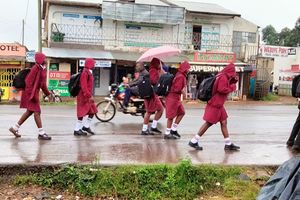
- The difference in height between parts of Nairobi also affects the drainage of the city. The law of gravity dictates that water flows downhill and with a flat area bordering a high area, it is no coincidence that Nairobi was described as a swamp by the British when setting up the city.
A little more than 100 years ago, the bustling city of Nairobi was an uninhabited swamp filled with wild animals.
The city came to be when the British took advantage of the last flat area they encountered before beginning the climb up the escarpment wall of the Rift Valley while constructing the Kenya-Uganda railway.
Where Nairobi stands today is where the British pitched camp for a breather before embarking on the difficult attempt to build the railway up and over the walls of the escarpment, into the Rift Valley and beyond.


The decision to pitch camp at Enkare Nyirobi, as it was known then, and the growth of the camp into the capital city has shaped and continues to shape the lives of its residents to date.
Before proceeding, it is good to understand the position of Nairobi relative to its surroundings for this piece to make sense. Nairobi lies a few kilometres to the east of the Rift Valley, with the closest distance being the 30 kilometres to Ngong’ Hills, which forms part of the escarpment.
Unique geography
Nairobi’s position next to the Rift Valley has given it a unique geography, with the city roughly divided into two halves of different heights. The western half of Nairobi is higher than the western half.
The fact that the city is quite small better highlights the difference in height between its western and western halves. The division between the eastern and western halves is marked by the Thika superhighway and Langata Road.
As you approach Nairobi’s eastern boundaries from Athi River, you are in a relatively flat area — the Athi plains. This flat area covers Ruiru, Kasarani, across Eastlands, Industrial Area, Nairobi National Park all the way to Rongai in the South.
The city experiences a sudden rise on its western side as the climb up the escarpment wall begins. This has made Nairobi areas such as Karen, Langata, Ngong’ Road, Westlands, Parklands, Gigiri all the way to Kiambu being higher than the areas on the eastern side.
The division between the low and high parts of Nairobi is marked by a slope that cuts across the city. The slope runs from Rongai crossing Magadi Road near Multimedia University. It extends all the way across the national park to emerge on Langata Road.
If you have been to a game drive at the national park, you must have noticed that you drive from a high area with lots of trees— where the nature trail and offices are located— to a low flat grassland.
The slope cuts across Langata Road near Uhuru Gardens, hence the elevation as you approach Langata. Beyond Nairobi Dam, the slope crosses Mbagathi Road near Highrise and extends all the way to Upper Hill behind Kenyatta Hospital, Kasneb and Madaraka estate. Along this particular stretch, the railway runs adjacent to the slope.
The slope approaches the Central Business District and can be clearly seen on Bunyala Road, near NIC Bank and the Railway Golf Club. Along this entire stretch, the average height above sea level increases by up to 100 metres.
Uhuru Park is perhaps the most famous stretch of this slope that continues its division of the city along State House Road and Kileleshwa to resurface clearly on Waiyaki Way near Chiromo. Beyond Westlands, the slope is seen in Parklands and runs adjacent to Thika Superhighway in Muthaiga past Garden Estate and beyond.
The difference in height between the eastern and western side of Nairobi has shaped the lives of its residents in different ways. It has influenced the zoning of the city— marking apart the rich and working class areas of Nairobi.
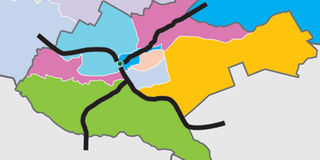
While Thika Superhighway and Langata Road divide the city into an eastern-western half, the Northern Corridor— Mombasa Road and Waiyaki Way— further divides the city to have a northern and southern half. The intersection of these four roads near the City centre divides the city into four quadrants.
The higher areas to the west of Nairobi are relatively ‘richer’ than the eastern half of the city. The upper western quadrant bordered by Thika Road and Waiyaki Way (quadrant 1/colour) is home to the super rich of Nairobi, Kenya and the region in general. This quadrant contains suburbs like Gigiri, Nyari, Runda, Kitisuru as well as the UN headquarters and high-end shopping malls.
The lower western quadrant bordered by Langata Road and Waiyaki Way (quadrant 2/colour) houses the upper middle class and includes estates like Kileleshwa, Lavington, Hurlingham and Adams Arcade. The edges of this quadrant have working class estates like Kawangware while the Karen suburb, which borders the escarpment at Ngong’, is also situated at the southern tip of this quadrant.
The lower eastern quadrant bordered by Langata Road and Mombasa Road (quadrant 3) is largely filled by the Nairobi National Park with estates like Rongai, South C and Nairobi West being on its edges.
The upper eastern quadrant bordered by Mombasa Road and Thika Highway (quadrant 4) is largely a working class area and an industrial zone.
This includes estates next to Thika Road like Mathare and Kasarani, estates along Outer Ring and Jogoo roads as well Embakasi and areas near the JKIA. It is also worth noting that the city’s two airports as well as the Moi Air Base are situated in the relatively flat eastern half of the city.
The difference in height between parts of Nairobi also affects the drainage of the city. The law of gravity dictates that water flows downhill and with a flat area bordering a high area, it is no coincidence that Nairobi was described as a swamp by the British when setting up the city.
Water flows eastwards whenever it rains and upon reaching the Eastern plains, it spreads out forming a flood plain that is best seen in the National Park. This explains why certain areas of the city experience flooding whenever it rains.
The areas that lie next to the slope including Rongai, South C, T-Mall, Nairobi West, Bunyala Road roundabout and Thika Superhighway at Pangani experience the worst of the flooding.
South C residents experience a rare phenomenon where it floods in the estate despite no rain falling in the area. Rain water from Langata, Karen and Ngong finds its way to South C and the National Park, causing floods in this flood plain. Indeed, South C has earned the infamous ‘South Sea’ tag due to the frequent floods. The above phenomenon also partly explains the images seen when flash floods caused parts of Thika Road to look like a river a few months back.
These areas that lie next to the slope need enhanced storm drainage to handle the excess water that flows from the high areas. The flooding saw the British plant Eucalyptus trees, which are known to drain swampy areas.
The trees, which are as old as the city, can be seen as you approach Upper Hill from Haile Selassie Avenue. The County Government of Nairobi can consider using these areas for water harvesting and extra drainage to reduce flooding in these places.
While Nairobi’s climate is more or less similar across the city, there are times when the weather varies from one part of the city to another. This phenomenon where one part of the city is cold and rainy while the other is dry and sunny is influenced by the difference in height.
Apart from the example of Langata, Karen and South C above, you find situations where it rains in Hurlingham, Kilimani and Kenyatta Hospital but it suddenly becomes sunny as you descend to the other end of Mbagathi Road at T-Mall.
The weather is also cooler on the Western side of Nairobi than the Eastern side. This is especially so in the morning as shown by the fog along Waiyaki Way and surrounding areas.
There is also a difference in the soil and vegetation in the eastern and western side of Nairobi. The higher western side is ‘greener’ with more fertile soils. This explains why the early settlers had coffee farms in the areas next to Kiambu Road. This particular area lies at the foot slopes of the Aberdares, which forms part of the escarpment.
The large coffee farms were later subdivided towards independence to form the affluent suburbs of Nairobi. Karen estate was also a farm made famous by Karen Blixen’s memoir, Out of Africa.
Beyond Nairobi towards the Rift, there is a steady increase in height with dramatic change of weather as you approach the peak of the escarpment.
This includes areas like Limuru, which have an average height of 2,200m above sea level, with the neighbouring Nairobi being 1,800m above sea level. Kinale Forest situated 20km from Naivasha is the peak of the escarpment along the Nairobi-Nakuru highway before the dramatic descent to Naivasha.
The increase in altitude over a small, compact area has given rise to a unique city that has the distinction of being the only city with a park in the world. Rivers, valleys, flood plains, hills, forests, dry areas and views of the Great Rift valley co-exist in this thriving city that is the biggest between Cape and Cairo.
A tour of the KICC helipad gives you a vantage point from where this features of Nairobi are clearly seen. Visit the helipad for Sh150 and get to appreciate the unique geography of this city and how it affects our everyday life as Nairobians.